Brown Engineering
Open menu
Open search
Brown Engineering
Skip Navigation Links
|
Teledyne Brown Engineering
|
What We Do
|
Markets
|
Space Systems
|
More About DESIS & MUSES
Multiple User System For Earth Sensing (MUSES)
Lau
nched June 2017, declared operational Oct 2017
Space-based two-axis gimbaling precision platform
Hosts up to four Earth-pointing/space-exposed instruments at one time
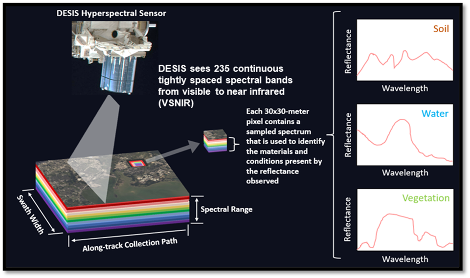
DLR Earth Sensing Imaging Spectrometer (DESIS)
Launched June 2018, installed August 2018, and declared operational November 2018
First instrument hosted on MUSES
Hyperspectral imager that detects fine spectral details of earth-based objects
Collects between 900 - 1100 km2 in each frame (dependent on altitude, AOI location, and off-nadir angle) with an approximate 30 m GSD (pixel) and capability of collecting up to 57,000 km2 in one continuous scan
230 million km2 + collected and in our archive
Summary of DESIS Terminology and Ground Sample Distance
MUSES/DESIS Coverage of Earth
DESIS Spectral Coverage is 400 to 1000 nanometers (nm)
The electromagnetic spectrum is composed of different wavelengths representing different types of light energy (e.g., visible, infrared, x-rays, etc.)
Materials interact with different parts of the spectrum in different ways that we can exploit in remote sensing using spectral fingerprints of vegetation, and other Earth cover
Human eyes perceive reflected colors in red, green, and blue (RGB) wavelength bands in the visible part of the spectrum from about 400 nm to 700 nm.
Non-visible spectral regions provide additional information
Hyperspectral data with hundreds of wavelengths covering visible and near-infrared spectral regions is a rich source of information about vegetation and other Earth cover features
This level of detail supports the discrimination and classification of materials, objects, and their conditions, based on features extracted from reflected sunlight, for example:
Tree and vegetation species (types and coverage)
Health (drought, pests, stress)
Water quality/algae detection
Soil constituents/certain minerals
Other ground features (roads, lakes, built-up areas)